News Article
UAV LiDAR Survey for Golf Simulation Game Development » UAV LiDAR Survey of Golf Course
WP_Post Object
(
[ID] => 1473
[post_author] => 2
[post_date] => 2025-06-10 11:45:54
[post_date_gmt] => 2025-06-10 10:45:54
[post_content] =>
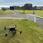
[post_title] => UAV LiDAR Survey of Golf Course
[post_excerpt] =>
[post_status] => inherit
[comment_status] => closed
[ping_status] => closed
[post_password] =>
[post_name] => st-andrews-old-course-17th-hole-photo-1
[to_ping] =>
[pinged] =>
[post_modified] => 2025-06-10 11:46:51
[post_modified_gmt] => 2025-06-10 10:46:51
[post_content_filtered] =>
[post_parent] => 1471
[guid] => https://www.geoterra.co.uk/wp-content/uploads/2025/06/St-Andrews-Old-Course-17th-Hole-Photo-1.png
[menu_order] => 0
[post_type] => attachment
[post_mime_type] => image/png
[comment_count] => 0
[filter] => raw
)