When you need accurate insight into the size, volume, depth, and extent of a submerged cavity below ground, your only option is a multibeam sonar survey.
Using FLODIM’s specialist multibeam sonar technology, we carry out investigations of submerged cavities across the UK and Ireland to provide engineers with accurate, georeferenced 3D data of such voids.
The voids we survey may be fully or partially filled with water, brine, liquid hydrocarbons, or gas, and are often difficult to access.
Whether you’re investigating flooded mine workings, water-filled culverts, or storage chambers, our multibeam sonar surveys provide you with the information you need to make informed decisions concerning remediation or maintenance.
With this survey, you get a complete picture of the void. This helps you to reduce risk, plan remediation or maintenance works, and manage complex underground voids safely and efficiently.
Need expert advice on surveying a submerged cavity?
Contact our team to discuss the best approach.
What is a submerged cavity?
A submerged cavity is an underground void, surrounded by soil or rock, that is partially or fully filled with liquid. These cavities may form through natural geological processes or be man-made, with many being historical and undocumented.
You might only discover a submerged cavity on site when:
- The ground collapses, or a sinkhole appears.
- Deep excavation or piling work uncovers a void.
- Infrastructure, such as roads, railways, or buildings, shows signs of movement or instability.
That’s when we are called in.
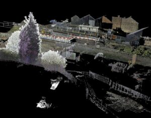
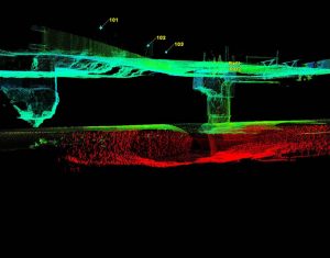
A multibeam sonar survey maps the submerged void in detail using FLODIM’s multibeam sonar lowered into a lined borehole. The sonar uses sound waves that travel through the liquid present and reflect off the cavity wall to capture highly accurate, georeferenced 3D data showing the cavity’s size, depths, volume, and extent.
Range of applications
We use the multibeam sonar to survey many types of submerged cavities, including:
- Natural voids – Created by natural processes, often in limestone karst systems.
- Old shallow mine workings – Abandoned or collapsed tunnels, shafts, and chambers from past mining.
- Mine shafts/tunnels – Vertical or horizontal excavations from past or current mining.
- Adits – Horizontal mine entrances, often used for drainage or access.
- Building cellars – Underground chambers below buildings, sometimes undocumented.
- Culverts – Underground drainage channels that can weaken or collapse over time.
- Historical tunnels – Disused or unrecorded tunnels, sometimes linked to transport.
- Structural voids – Hollow areas under bridges, foundations, or other structures.
- Storage chambers – Used for storing brine, liquid hydrocarbons, gas, or water underground.
Want to see how we’ve handled similar projects?
View our case studies to see real examples.
How do we survey submerged cavities?
As FLODIM’s exclusive partner in the UK and Ireland, we use their specialist multibeam sonar technology to survey submerged cavities below ground.
Before we deploy the sonar, we carry out essential checks using FLODIM’s Explorer G2 to inspect the integrity of the void, including the assessment of the depth of the void, the presence of liquid, and if conditions are safe for the deployment of high-cost equipment.
Once conditions are confirmed as suitable, the sonar is lowered down a 100 mm internal diameter lined borehole, which must extend to the top of the cavity, allowing it to be mapped in detail and with precision.
Key capabilities of the sonar include:
- Surveys cavities up to 1,500 m below ground.
- Scans spaces up to 100 m in length or radius from the borehole entry.*
- Captures measurements with ±2 cm resolution and ±3 cm accuracy.
- Fully georeferenced, 360-degree domed survey relative to the borehole surface location.
- Onboard gyro records the cavity’s orientation.
*The sonar cannot see around corners, so additional boreholes may be required to fully survey the cavity.
If, however, the cavity can be drained before our team is mobilised to the site, we can instead carry out a dry cavity subsurface laser scan survey, providing equally precise data.
Have an urgent project?
We can deploy a team quickly to site to deliver fast, accurate survey data in emergency scenarios. Request a quote today.
Survey data we can deliver
Once a survey is complete, we will provide you with a:
- Georeferenced 3D point cloud model of the void supplied in LAS and DXF formats.
- Comprehensive written report setting out our findings.
This data removes any guesswork, helping you to reduce risks, control costs, and manage safety.
Why this information matters
Surveying a submerged cavity provides you with the detailed information needed to fully understand what is happening below ground before conditions worsen. Accurate data on the size, shape, depth, and extent of a flooded voids allows risks to be properly assessed, rather than relying on assumptions or incomplete records.
This survey data is critical for identifying breaches in underground infrastructure and determining whether a cavity is stable or continuing to deteriorate. It also supports effective planning of remediation or maintenance works, helping to reduce the risk of further ground failure, protect infrastructure, and avoid unexpected costs or delays to a construction project.
Ready to survey a submerged cavity?
Contact us today to discuss your project.
Looking to investigate a dry void?
If you have discovered a dry void that needs investigating on-site, look at our Subsurface Laser Scan Surveys of Dry Cavities service to see how we can help.