Projects
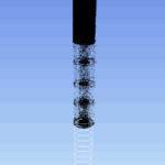
Creswell Colliery Historic Mine Shaft Survey
We were appointed by the Mining Remediation Authority (MRA) to survey a historic mine shaft at the former Creswell Colliery.
After the colliery closed in 1991, the shaft had been mothballed and slowly filled with water once the... Read more
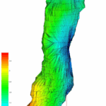
Multibeam Sonar Survey of a Brine Cavity (H222)
We were appointed by INEOS Inovyn to survey a brine cavity (H222) of approximately 1.2 million cubic metres located beneath a 1,600-hectare brinefield, as part of their brine cavity logging programme.
Northwich is a historic salt town where brine mining and processing continue today by INEOS to... Read more
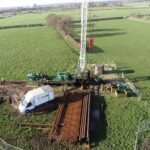
Multibeam Sonar Survey of an Old Mine Shaft and Drainage Adit
We were requested by the Mining Remediation Authority (MRA) to survey a legacy mine shaft and connecting drainage adit following a significant ‘blowout’ event in a residential area.
The drainage adit, originally built to channel water away from the mine... Read more
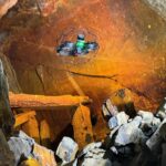
Historic Lead Mine Adit and New Drainage Tunnel 3D Laser Scan Survey
Geoterra was appointed by civil engineers, Walters Group, to carry out an above- and below-ground 3D laser scan survey of a historic lead mine adit (Adit 9) and a newly installed drainage tunnel connecting to the adit. Walters Group... Read more

Clifton Hall Tunnel Subsurface Laser Scan Survey
Geoterra was engaged by M&J Drilling on behalf of AmcoGiffen and Jacobs Consulting Engineers to carry out a series of subsurface 3D laser scan surveys of the disused Clifton Hall Tunnel beneath Swinton Football Club in Swinton, Greater... Read more

3D Surface and Subsurface Survey of Islington Tunnel
The Canal & River Trust appointed Geoterra to carry out a combined 3D mobile mapping laser scan and bathymetric multibeam sonar survey of the Islington Tunnel on Regent’s Canal.
The tunnel runs beneath Islington, stretching 878 meters from Caledonian Road to... Read more
Services
News

Get In Touch
Winnington Hall
Winnington Lane
Northwich
Cheshire
CW8 4DU
Phone: +44 (0)1606 659019Fax: Not AvailableEmail: info@geoterra.co.uk


