Civil Engineering - Projects

Clifton Hall Tunnel Subsurface Laser Scan Survey
Geoterra was engaged by M&J Drilling on behalf of AmcoGiffen and Jacobs Consulting Engineers to carry out a series of subsurface 3D laser scan surveys of the disused Clifton Hall Tunnel beneath Swinton Football Club in Swinton, Greater... Read more

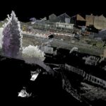
3D Surface and Subsurface Survey of Islington Tunnel
The Canal & River Trust appointed Geoterra to carry out a combined 3D mobile mapping laser scan and bathymetric multibeam sonar survey of the Islington Tunnel on Regent’s Canal.
The tunnel runs beneath Islington, stretching 878 meters from Caledonian Road to... Read more
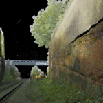
3D Laser Scan Survey of Sandstone Rockface Adjacent to Railway Line
Geoterra was appointed by Murphy Group and Coffey Geotechnics to conduct an extensive 3D laser scan survey of a sandstone rock face and surrounding area. The survey area spanned approximately 100 meters along the primary railway line from Manchester to... Read more
Sonar survey of a water-filled coal mine roadway beneath railway station
A new railway station was due to be constructed in Willenhall, Staffordshire on the Wolverhampton to Walsall mainline.
Historic mine plans indicated that a coal mine roadway was situated directly beneath where the proposed new railway station was to be built.... Read more
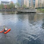
Subsurface Bathymetric Sonar Survey of the River Irwell
Geoterra was appointed by clients Arcadis and Peel Ports to carry out a subsurface bathymetric sonar scan survey on the River Irwell at Clippers Quay in Salford.
The survey was required to help the clients to ascertain the riverbed levels and... Read more
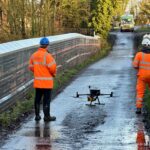
UAV LiDAR Survey of a Railway Cutting on the Chiltern Rail Line
Geoterra was appointed by Coffey Geotechnics, The Murphy Group and Network Rail to complete a UAV aerial survey of a railway cutting on the Chiltern line in Harbury, Warwickshire. They required both low level LiDAR survey and a HD ortho... Read more
Services
News

Get In Touch
Winnington Hall
Winnington Lane
Northwich
Cheshire
CW8 4DU
Phone: +44 (0)1606 659019Fax: Not AvailableEmail: info@geoterra.co.uk


