3D Laser Scan Survey - Projects
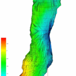
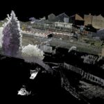
Multibeam Sonar Survey of a Brine Cavity (H222)
We were appointed by INEOS Inovyn to survey a brine cavity (H222) of approximately 1.2 million cubic metres located beneath a 1,600-hectare brinefield, as part of their brine cavity logging programme.
Northwich is a historic salt town where brine mining and processing continue today by INEOS to... Read more
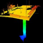
Multibeam Sonar Survey of an Old Mine Shaft and Drainage Adit
We were requested by the Mining Remediation Authority (MRA) to survey a legacy mine shaft and connecting drainage adit following a significant ‘blowout’ event in a residential area.
The drainage adit, originally built to channel water away from the mine... Read more
Subsurface Laser Scan and Multibeam Sonar Survey of Former Historical Coal Mine Shaft
Geoterra was contracted by The Coal Authority to survey a partially submerged coal mine shaft in the UK. The survey aimed to assess the structural integrity of the shaft, which had partially collapsed and was filling with water after mine... Read more
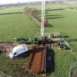
3D Laser Scan Survey of Sandstone Rockface Adjacent to Railway Line
Geoterra was appointed by Murphy Group and Coffey Geotechnics to conduct an extensive 3D laser scan survey of a sandstone rock face and surrounding area. The survey area spanned approximately 100 meters along the primary railway line from Manchester to... Read more
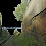
Sonar survey of a water-filled coal mine roadway beneath railway station
A new railway station was due to be constructed in Willenhall, Staffordshire on the Wolverhampton to Walsall mainline.
Historic mine plans indicated that a coal mine roadway was situated directly beneath where the proposed new railway station was to be built.... Read more
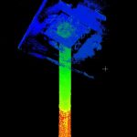
Subsurface Laser Scan Survey of Historic Lead Mine Shaft
Geoinvestigate appointed Geoterra to carry out a 3D subsurface laser scan and HD video survey of a historic lead mine shaft. The mine potentially dated back to the 1700s when the Talargoch mine was extracting lead ore. The lead mine... Read more
Services
News

Get In Touch
Winnington Hall
Winnington Lane
Northwich
Cheshire
CW8 4DU
Phone: +44 (0)1606 659019Fax: Not AvailableEmail: info@geoterra.co.uk


