Projects
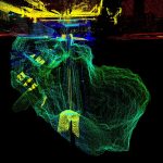
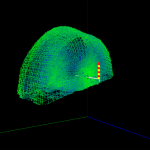
Kilbowie Road Mine Shaft
Following a major ground collapse on Kilbowie Road in Clydebank, Geoterra were appointed by Soil Engineering and The Coal Authority to carry out an urgent mine shaft survey.
Kilbowie Road is a major artery road into Glasgow city. The... Read more
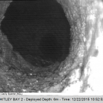
Whitley Bay Old Mining Void
Dunelm Geotechnical & Environmental and Kier appointed Geoterra to carry out an as-built 3D subsurface laser scan survey of a void discovered beneath the promenade at Whitley Bay in North Shields, Northumberland
The survey data was required by Kier to enable... Read more
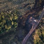
Brechfa Windfarm
Geoterra was appointed by consultant engineers Tony Gee, on behalf of civil engineering contractors Farrans, to carry out a full UAV aerial mapping survey of Brechfa windfarm. This survey data was required in preparation for the extension of an existing... Read more
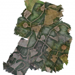
Harburnhead Windfarm
Geoterra was appointed by consultant engineers Tony Gee, on behalf of civil engineering contractors Farrans, to carry out a full UAV aerial mapping survey of Harburnhead windfarm. This survey data was required in preparation for the development of a new... Read more

Warmwell Quarry
Geoterra was appointed by consultant engineers Peter Brett Associates, on behalf of developers Habitat First Group, to carry out a full UAV aerial mapping survey of Warmwell Quarry and Silverlakes. This survey data was required in preparation for the property... Read more
Network Rail Bridge
Storm Geomatics and Arcadis Consulting Engineers appointed Geoterra to carry out a 3D subsurface laser scan as-built survey of voids discovered within a Network Rail bridge in Rugby, Warwickshire.
The survey data was required by Arcadis Consulting Engineers to enable... Read more
Services
News

Get In Touch
Winnington Hall
Winnington Lane
Northwich
Cheshire
CW8 4DU
Phone: +44 (0)1606 659019Fax: Not AvailableEmail: info@geoterra.co.uk


