Projects
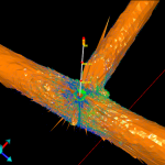
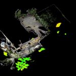
Waverley Train Station Arch Voids & Culvert
Geoterra was appointed by the Aspin Group and Story Contracting to carry out a 3D subsurface laser scan survey of buried culverts beneath the proposed rail line extension at Waverley Railway Station in Edinburgh.
The survey data was required by the... Read more
Lang Loan Limestone Voids
Geoterra was appointed by Van Elle Ground Engineers to carry out a 3D subsurface laser scan survey of a historic limestone mine discovered beneath a construction site earmarked for new homes in Straiton, Edinburgh.
The survey data was required to assess... Read more
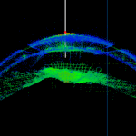
Caeau Shaft and Milwr Tunnel
Geoterra was appointed by Wardell Armstrong to carry out a 3D subsurface laser scan survey of the Milwr Tunnel at a disused lead mine. A 3D laser scan survey of the surface was also required of the locale around the... Read more
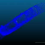
Clifton Hall Disused Railway Tunnel Survey
Geoterra was appointed by M & J Drilling to carry out a 3D subsurface laser scan survey of a disused railway tunnel discovered beneath Victoria Park in Swinton, Greater Manchester.
The survey data was required by the client to assess the... Read more
Pinner Wood School
Following the discovery of a shaft collapse on the grounds of Pinner Wood School in Harrow, London, further intrusive investigations discovered unmapped old chalk mines beneath the school buildings.
Harrow Council and Peter Brett Associates LLP required Geoterra to... Read more
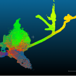
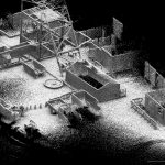
Ecton Mine
UNEXMIN required a full laser scan survey of the entire accessible mine system at Ecton Mine in the River Manifold Valley, Staffordshire.
UNEXMIN and the Ecton Mine Trust required Geoterra to carry out laser scan surveys in order to produce a... Read more
Services
News

Get In Touch
Winnington Hall
Winnington Lane
Northwich
Cheshire
CW8 4DU
Phone: +44 (0)1606 659019Fax: Not AvailableEmail: info@geoterra.co.uk


