Projects
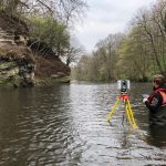
Salvesen Steps 3D Laser Scan Survey
Geoterra was appointed by Edinburgh Council and SWECO to carry out a highly detailed 3D laser scan and UAV LiDAR survey of a rock face and adjacent land that ran approximately 150m along the River Almond incorporating the Weir, Cramond... Read more
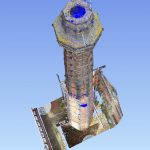
3D Laser Scan Survey of Victorian Brick-Built Chimney
Geoterra was appointed by The Canal and River Trust to carry out a 3D topographical laser scan survey both internally and externally of a historic Victorian brick-built chimney at the National Waterways Museum, Ellesmere Port, Cheshire.
The survey data was required... Read more
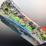
A UAV LiDAR and Photogrammetry Survey of King George V Memorial Embankment
Geoterra was appointed by Cormac Consulting to carry out a UAV survey using photogrammetry and low-level LiDAR techniques on a residential/leisure land, which had moderate low-level vegetation cover at the time of the survey adjacent to the tidal estuary at... Read more
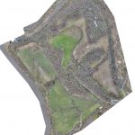
Aerial LiDAR and Photogrammetry Survey of Witton Landfill
Geoterra was appointed by Coopers and Cheshire West & Cheshire Council to carry out a UAV survey using photogrammetry and low-level LiDAR techniques on a former refuse and landfill site adjacent to the River Weaver in Carey Park, Northwich.
The survey... Read more
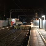
Survey of Submerged Void Beneath Train Station Platform
Geoterra was appointed by Arcadis, Galliford Try and Network Rail to carry out a subsurface multibeam sonar scan survey of a submerged void discovered beneath Platform 4 at Kidsgrove Station in Staffordshire. A surface laser scan would also be carried... Read more
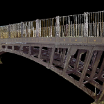
3D Laser Scan Survey of a Pedestrian Bridge Understructure
Geoterra was appointed by WSP Consulting Engineers to carry out a 3D laser scan survey of the top and understructure of a Grade II listed former toll, now a pedestrian bridge at Newlay Lane, Horsforth.
The survey data was required by... Read more
Services
News

Get In Touch
Winnington Hall
Winnington Lane
Northwich
Cheshire
CW8 4DU
Phone: +44 (0)1606 659019Fax: Not AvailableEmail: info@geoterra.co.uk


