Underground Surveying - Projects

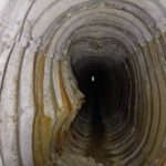
Clifton Hall Tunnel Subsurface Laser Scan Survey
Geoterra was engaged by M&J Drilling on behalf of AmcoGiffen and Jacobs Consulting Engineers to carry out a series of 3D laser scan surveys of the disused Clifton Hall Tunnel beneath Swinton Football Club in Swinton, Greater Manchester.... Read more
Subsurface Laser Scan and Multi-beam Sonar Survey of Former Historical Coal Mine Shaft
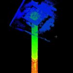
Geoterra was contracted by The Coal Authority to survey a partially submerged coal mine shaft in the UK. The survey aimed to assess the structural integrity of the shaft, which had partially collapsed and was filling with water after mine... Read more
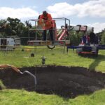
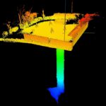
Underground 3D laser scan survey of second sinkhole and bell pit on playing field
In February 2020, Geoterra surveyed a sinkhole and bell pit that had appeared on Sappers Field in Wooburn Green. This sinkhole and bell pit was backfilled and remediated by Soil Engineering in 2022.
Prior to being a playing field, the... Read more
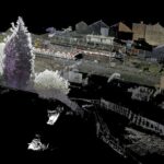
Aerial photogrammetry survey of 21 underground drainage adits
Folkestone Warren is an area of land prone to landslides. In December 1915, a severe landslip at Folkestone Warren, known as The Great Fall, resulted in train derailments and continued rail movement on the Dover to London South Eastern... Read more
Sonar survey of a water-filled coal mine roadway beneath railway station
A new railway station was due to be constructed in Willenhall, Staffordshire on the Wolverhampton to Walsall mainline.
Historic mine plans indicated that a coal mine roadway was situated directly beneath where the proposed new railway station was to be built.... Read more
Subsurface Laser Scan Survey of Historic Lead Mine Shaft
Geoinvestigate appointed Geoterra to carry out a 3D subsurface laser scan and HD video survey of a historic lead mine shaft. The mine potentially dated back to the 1700s when the Talargoch mine was extracting lead ore. The lead mine... Read more
Services
News

Get In Touch
Winnington Hall
Winnington Lane
Northwich
Cheshire
CW8 4DU
Phone: +44 (0)1606 659019Fax: Email: [email protected]


