Underground Surveying - Projects

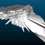
Historic Coal Mine Subsurface Laser Scan Survey
Geoterra was appointed by The Coal Authority to determine the location, size and orientation of an historical coal mine void that had been discovered beneath a main road and its adjacent properties.
The coal mine had been discovered... Read more
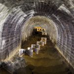
Dunford Bridge Drainage Culvert Survey
Geoterra was appointed by WSP Consultant Engineers to carry out a 3D topographical survey of a confined space drainage culvert that runs directly underneath the Trans Pennine Way at Dunford Bridge in South Yorkshire.
The survey data was required to assess... Read more
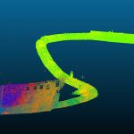
Port Immingham Submerged Void Survey
Geoterra was appointed by ABP and DFDS to carry out a subsurface multibeam sonar scan survey of a submerged void discovered beneath Berth 11 at Port of Immingham in Lincolnshire. A 3D CAD plan drawing had already been created so... Read more
Subsurface Laser Scan Survey of Drainage Culverts
Geoterra was appointed by the Environment Agency to carry out a 3D topographical laser subsurface scan survey of a series of drainage culverts running beneath both property and transport links in Skipton, North Yorkshire.
The survey data was required to assess... Read more
Services
News


Get In Touch
Winnington Hall
Winnington Lane
Northwich
Cheshire
CW8 4DU
Phone: +44 (0)1606 659019Email: info@geoterra.co.uk


