Aerial LiDAR Survey - Projects
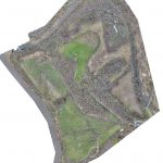
Aerial LiDAR and Photogrammetry Survey of Witton Landfill
Geoterra was appointed by Coopers and Cheshire West & Cheshire Council to carry out a UAV survey using photogrammetry and low-level LiDAR techniques on a former refuse and landfill site adjacent to the River Weaver in Carey Park, Northwich.
The survey... Read more
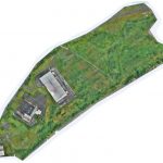
Industrial Land UAV LiDAR and Photogrammetry Survey
Geoterra was appointed by Peel L&P to carry out a UAV survey using photogrammetry and low-level LiDAR techniques on industrial and heavily vegetated disused development land adjacent to the AJ Bell Stadium and Manchester Ship Canal in Port Salford, Irlam... Read more
Services
News

Get In Touch
Geoterra,
Winnington Hall
Winnington Lane
Northwich
Cheshire
CW8 4DU
Winnington Hall
Winnington Lane
Northwich
Cheshire
CW8 4DU
Phone: +44 (0)1606 659019Fax: Not AvailableEmail: info@geoterra.co.uk


© Geoterra 2026 Website by Global River