UAV Aerial Surveying - Projects
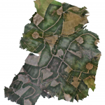
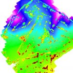
Brechfa Windfarm
Geoterra was appointed by consultant engineers Tony Gee, on behalf of civil engineering contractors Farrans, to carry out a full UAV aerial mapping survey of Brechfa windfarm. This survey data was required in preparation for the extension of an existing... Read more
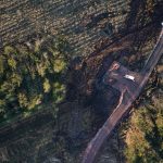
Harburnhead Windfarm
Geoterra was appointed by consultant engineers Tony Gee, on behalf of civil engineering contractors Farrans, to carry out a full UAV aerial mapping survey of Harburnhead windfarm. This survey data was required in preparation for the development of a new... Read more
Stanton-on-the-Wolds Golf Club
Stanton-on-the-Wolds Golf Club required a full topographical survey for a redesign of the 18-hole parkland golf course. The project includes future planned extensions to the golf course and new holes.
Severn Partnership commissioned Geoterra to carry out a UAV aerial survey... Read more
Services
News

Get In Touch
Winnington Hall
Winnington Lane
Northwich
Cheshire
CW8 4DU
Phone: +44 (0)1606 659019Fax: Email: [email protected]


