Laser Scanning - Projects

Historic Coal Mine Subsurface Laser Scan Survey
Geoterra was appointed by The Coal Authority to determine the location, size and orientation of an historical coal mine void that had been discovered beneath a main road and its adjacent properties.
The coal mine had been discovered... Read more
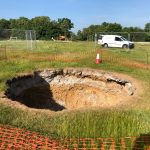
Subsurface laser scan survey of sinkhole in playing field
Geoterra was appointed by Wooburn & Bourne End Parish Council to carry out a 3D subsurface laser scan and video survey of a recently discovered sinkhole in a playing field.
A 3D laser surface survey scan was also required of the... Read more
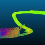
Subsurface Laser Scan Survey of Drainage Culverts
Geoterra was appointed by the Environment Agency to carry out a 3D topographical laser subsurface scan survey of a series of drainage culverts running beneath both property and transport links in Skipton, North Yorkshire.
The survey data was required to assess... Read more
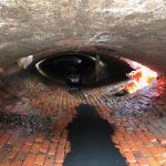
Munton’s Embankment Culvert Laser Scan Survey
Geoterra was appointed by Taziker Industrial to carry out a 3D topographical laser subsurface scan survey of a drainage culvert running beneath the railway embankment in Stowmarket, Suffolk.
The survey data was required to assess the location and alignment of the... Read more
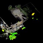
Pinner Wood School
Following the discovery of a shaft collapse on the grounds of Pinner Wood School in Harrow, London, further intrusive investigations discovered unmapped old chalk mines beneath the school buildings.
Harrow Council and Peter Brett Associates LLP required Geoterra to... Read more
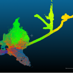
Ecton Mine
UNEXMIN required a full laser scan survey of the entire accessible mine system at Ecton Mine in the River Manifold Valley, Staffordshire.
UNEXMIN and the Ecton Mine Trust required Geoterra to carry out laser scan surveys in order to produce a... Read more
Services
News

Get In Touch
Winnington Hall
Winnington Lane
Northwich
Cheshire
CW8 4DU
Phone: +44 (0)1606 659019Fax: Email: info@geoterra.co.uk


