Subsurface Laser Scanning - Projects
Network Rail Bridge
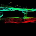
Storm Geomatics and Arcadis Consulting Engineers appointed Geoterra to carry out a 3D subsurface laser scan as-built survey of voids discovered within a Network Rail bridge in Rugby, Warwickshire.
The survey data was required by Arcadis Consulting Engineers to enable... Read more

Battersea Power Station
Geoterra was appointed by civil engineering contractors, Cementation Skanska to carry out subsurface multibeam sonar survey to identify the location and structure of inlet and outlet tunnels. This survey data was required in preparation for a future development by... Read more
Caeau Shaft
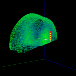
Geoterra was appointed by Wardell Armstrong to carry out a subsurface laser scan survey of Caeau Shaft at Milwr Tunnel in North Wales.
Consulting engineers Wardell Armstrong required three-dimensional geospatial data to determine the exact shape and dimensions of the upper... Read more
Shieldhall Strategic Tunnel
The £100 million Shieldhall Tunnel in Glasgow is designed to alleviate pressure on the existing waste water network. It achieves this by providing additional storm water storage, reduces the risk of flooding and improving the water quality in the River... Read more
Chester Road
Geoterra was appointed by a firm of building contractors to carry out a topographical survey, subsurface laser scan survey and multibeam sonar survey to identify the location and structure of a culvert at Chester Road in the City of Manchester,... Read more
Services
News


Get In Touch
Winnington Hall
Winnington Lane
Northwich
Cheshire
CW8 4DU
Phone: +44 (0)1606 659019Email: info@geoterra.co.uk


