Mining and Minerals - Projects
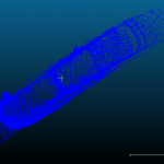
Sonar survey of a water-filled coal mine roadway beneath railway station
A new railway station was due to be constructed in Willenhall, Staffordshire on the Wolverhampton to Walsall mainline.
Historic mine plans indicated that a coal mine roadway was situated directly beneath where the proposed new railway station was to be built.... Read more
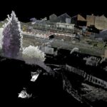
Subsurface Laser Scan Survey of Historic Lead Mine Shaft
Geoinvestigate appointed Geoterra to carry out a 3D subsurface laser scan and HD video survey of a historic lead mine shaft. The mine potentially dated back to the 1700s when the Talargoch mine was extracting lead ore. The lead mine... Read more

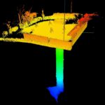
Historic Coal Mine Subsurface Laser Scan Survey
Geoterra was appointed by The Coal Authority to determine the location, size and orientation of an historical coal mine void that had been discovered beneath a main road and its adjacent properties.
The coal mine had been discovered... Read more
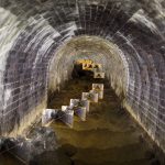
Dunford Bridge Drainage Culvert Survey
Geoterra was appointed by WSP Consultant Engineers to carry out a 3D topographical survey of a confined space drainage culvert that runs directly underneath the Trans Pennine Way at Dunford Bridge in South Yorkshire.
The survey data was required to assess... Read more
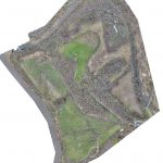
Aerial LiDAR and Photogrammetry Survey of Witton Landfill
Geoterra was appointed by Coopers and Cheshire West & Cheshire Council to carry out a UAV survey using photogrammetry and low-level LiDAR techniques on a former refuse and landfill site adjacent to the River Weaver in Carey Park, Northwich.
The survey... Read more
Lang Loan Limestone Voids
Geoterra was appointed by Van Elle Ground Engineers to carry out a 3D subsurface laser scan survey of a historic limestone mine discovered beneath a construction site earmarked for new homes in Straiton, Edinburgh.
The survey data was required to assess... Read more
Services
News

Get In Touch
Winnington Hall
Winnington Lane
Northwich
Cheshire
CW8 4DU
Phone: +44 (0)1606 659019Fax: Not AvailableEmail: info@geoterra.co.uk


