Mining and Minerals - Projects
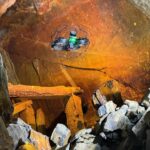
Historic Lead Mine Adit and New Drainage Tunnel 3D Laser Scan Survey
Geoterra was appointed by civil engineers, Walters Group, to carry out an above- and below-ground 3D laser scan survey of a historic lead mine adit (Adit 9) and a newly installed drainage tunnel connecting to the adit. Walters Group... Read more
Subsurface Laser Scan and Multi-beam Sonar Survey of Former Historical Coal Mine Shaft
Geoterra was contracted by The Coal Authority to survey a partially submerged coal mine shaft in the UK. The survey aimed to assess the structural integrity of the shaft, which had partially collapsed and was filling with water after mine... Read more
Sonar survey of a water-filled coal mine roadway beneath railway station
A new railway station was due to be constructed in Willenhall, Staffordshire on the Wolverhampton to Walsall mainline.
Historic mine plans indicated that a coal mine roadway was situated directly beneath where the proposed new railway station was to be built.... Read more
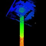
Subsurface Laser Scan Survey of Historic Lead Mine Shaft
Geoinvestigate appointed Geoterra to carry out a 3D subsurface laser scan and HD video survey of a historic lead mine shaft. The mine potentially dated back to the 1700s when the Talargoch mine was extracting lead ore. The lead mine... Read more

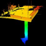
Historic Coal Mine Subsurface Laser Scan Survey
Geoterra was appointed by The Coal Authority to determine the location, size and orientation of an historical coal mine void that had been discovered beneath a main road and its adjacent properties.
The coal mine had been discovered... Read more
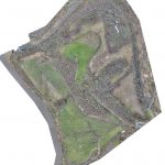
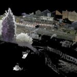
Aerial LiDAR and Photogrammetry Survey of Witton Landfill
Geoterra was appointed by Coopers and Cheshire West & Cheshire Council to carry out a UAV survey using photogrammetry and low-level LiDAR techniques on a former refuse and landfill site adjacent to the River Weaver in Carey Park, Northwich.
The survey... Read more
Services
News

Get In Touch
Winnington Hall
Winnington Lane
Northwich
Cheshire
CW8 4DU
Phone: +44 (0)1606 659019Fax: Not AvailableEmail: info@geoterra.co.uk


