Lidar Survey - Projects
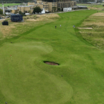
UAV LiDAR Survey for Golf Simulation Game Development
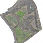
Geoterra was engaged by an international gaming software developer to carry out a UAV LiDAR survey of the prestigious Old Course at St Andrews Links golf course in Scotland. The data collected would be used to support the development... Read more
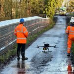
UAV LiDAR Survey of a Railway Cutting on the Chiltern Rail Line
Geoterra was appointed by Coffey Geotechnics, The Murphy Group and Network Rail to complete a UAV aerial survey of a railway cutting on the Chiltern line in Harbury, Warwickshire. They required both low level LiDAR survey and a HD ortho... Read more
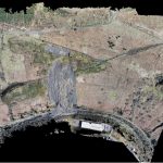
Tylorstown Landslide UAV LiDAR & Photogrammetry Survey
Geoterra was appointed by The Coal Authority, Capita and Rhondda Cyon Taf Council to carry out a UAV survey using both low-level LiDAR techniques and photogrammetry on a landslide that occurred on a historic legacy coal tip, together with adjacent... Read more

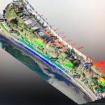
Aerial LiDAR and Photogrammetry Survey of River Usk Embankment
Geoterra was appointed by Newport Council and Capita Property & Infrastructure to monitor a stretch of River Usk embankment for movement using a low-level UAV LiDAR and photogrammetry survey of several phases at monthly intervals. This would be an ongoing... Read more
A UAV LiDAR and Photogrammetry Survey of King George V Memorial Embankment
Geoterra was appointed by Cormac Consulting to carry out a UAV survey using photogrammetry and low-level LiDAR techniques on a residential/leisure land, which had moderate low-level vegetation cover at the time of the survey adjacent to the tidal estuary at... Read more
Aerial LiDAR and Photogrammetry Survey of Witton Landfill
Geoterra was appointed by Coopers and Cheshire West & Cheshire Council to carry out a UAV survey using photogrammetry and low-level LiDAR techniques on a former refuse and landfill site adjacent to the River Weaver in Carey Park, Northwich.
The survey... Read more
Services
News

Get In Touch
Winnington Hall
Winnington Lane
Northwich
Cheshire
CW8 4DU
Phone: +44 (0)1606 659019Fax: Email: [email protected]


