UAV Drone Surveys - Projects

UAV LiDAR Survey of a Railway Cutting on the Chiltern Rail Line
Geoterra was appointed by Coffey Geotechnics, The Murphy Group and Network Rail to complete a UAV aerial survey of a railway cutting on the Chiltern line in Harbury, Warwickshire. They required both low level LiDAR survey and a HD ortho... Read more
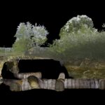
Subsurface Laser Scan and UAV Photogrammetry Survey of Air Raid Shelter
Geoterra was appointed by M-AR and Bromley Council to carry out a 3D topographical laser scan survey above and below ground, as well as a remote UAV photographic survey of a historic air raid shelter. The air raid shelter had... Read more

UAV survey of listed building, Winnington Hall
Winnington Hall is a former country house in Winnington, now a suburb of Northwich, Cheshire, England. It is recorded in the National Heritage List for England as a designated Grade I listed building. The building is in effect two houses joined together, an older modest timber-framed house, and a newer, more elegant,... Read more

UAV photogrammetry survey of St John’s Church
Geoterra was invited by St John’s Church Parish Council to carry out a UAV photogrammetry survey of the historic sandstone church. It was built in 1873, with the tower subsequently added in 1887 and a new modern extension completed in... Read more
Tylorstown Landslide UAV LiDAR & Photogrammetry Survey
Geoterra was appointed by The Coal Authority, Capita and Rhondda Cyon Taf Council to carry out a UAV survey using both low-level LiDAR techniques and photogrammetry on a landslide that occurred on a historic legacy coal tip, together with adjacent... Read more

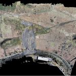
Aerial LiDAR and Photogrammetry Survey of River Usk Embankment
Geoterra was appointed by Newport Council and Capita Property & Infrastructure to monitor a stretch of River Usk embankment for movement using a low-level UAV LiDAR and photogrammetry survey of several phases at monthly intervals. This would be an ongoing... Read more
Services
News

Get In Touch
Winnington Hall
Winnington Lane
Northwich
Cheshire
CW8 4DU
Phone: +44 (0)1606 659019Fax: Not AvailableEmail: info@geoterra.co.uk


