Land Survey - Projects
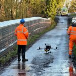
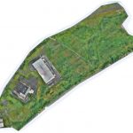
UAV LiDAR Survey of a Railway Cutting on the Chiltern Rail Line
Geoterra was appointed by Coffey Geotechnics, The Murphy Group and Network Rail to complete a UAV aerial survey of a railway cutting on the Chiltern line in Harbury, Warwickshire. They required both low level LiDAR survey and a HD ortho... Read more
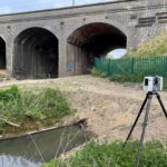
Drainage Culvert Survey Beneath East Coast Main Line
Geoterra was appointed by AMCO Giffen and Network Rail to carry out a 3D topographical laser scan survey of the surface, and a subsurface laser scan and remote UAV photogrammetry survey of a brick-built drainage culvert. This culvert had been... Read more
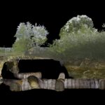
Subsurface Laser Scan and UAV Photogrammetry Survey of Air Raid Shelter
Geoterra was appointed by M-AR and Bromley Council to carry out a 3D topographical laser scan survey above and below ground, as well as a remote UAV photographic survey of a historic air raid shelter. The air raid shelter had... Read more
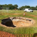
Subsurface laser scan survey of sinkhole in playing field
Geoterra was appointed by Wooburn & Bourne End Parish Council to carry out a 3D subsurface laser scan and video survey of a recently discovered sinkhole in a playing field.
A 3D laser surface survey scan was also required of the... Read more
Industrial Land UAV LiDAR and Photogrammetry Survey
Geoterra was appointed by Peel L&P to carry out a UAV survey using photogrammetry and low-level LiDAR techniques on industrial and heavily vegetated disused development land adjacent to the AJ Bell Stadium and Manchester Ship Canal in Port Salford, Irlam... Read more
Services
News

Get In Touch
Winnington Hall
Winnington Lane
Northwich
Cheshire
CW8 4DU
Phone: +44 (0)1606 659019Fax: Not AvailableEmail: info@geoterra.co.uk


