UAV Aerial Surveying - Projects
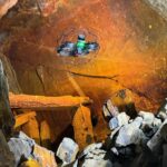
Historic Lead Mine Adit and New Drainage Tunnel 3D Laser Scan Survey
Geoterra was appointed by civil engineers, Walters Group, to carry out an above- and below-ground 3D laser scan survey of a historic lead mine adit (Adit 9) and a newly installed drainage tunnel connecting to the adit. Walters Group... Read more

UAV LiDAR Survey for Golf Simulation Game Development
Geoterra was engaged by an international gaming software developer to carry out a UAV LiDAR survey of the prestigious Old Course at St Andrews Links golf course in Scotland. The data collected would be used to support the development... Read more
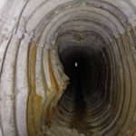
Aerial photogrammetry survey of 21 underground drainage adits
Folkestone Warren is an area of land prone to landslides. In December 1915, a severe landslip at Folkestone Warren, known as The Great Fall, resulted in train derailments and continued rail movement on the Dover to London South Eastern... Read more

UAV LiDAR Survey of a Railway Cutting on the Chiltern Rail Line
Geoterra was appointed by Coffey Geotechnics, The Murphy Group and Network Rail to complete a UAV aerial survey of a railway cutting on the Chiltern line in Harbury, Warwickshire. They required both low level LiDAR survey and a HD ortho... Read more
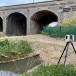
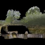
Drainage Culvert Survey Beneath East Coast Main Line
Geoterra was appointed by AMCO Giffen and Network Rail to carry out a 3D topographical laser scan survey of the surface, and a subsurface laser scan and remote UAV photogrammetry survey of a brick-built drainage culvert. This culvert had been... Read more
Subsurface Laser Scan and UAV Photogrammetry Survey of Air Raid Shelter
Geoterra was appointed by M-AR and Bromley Council to carry out a 3D topographical laser scan survey above and below ground, as well as a remote UAV photographic survey of a historic air raid shelter. The air raid shelter had... Read more
Services
News

Get In Touch
Winnington Hall
Winnington Lane
Northwich
Cheshire
CW8 4DU
Phone: +44 (0)1606 659019Fax: Not AvailableEmail: info@geoterra.co.uk


