Subsurface laser scan survey of sinkhole in playing field
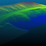
Tylorstown Landslide UAV LiDAR & Photogrammetry Survey
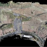
Aerial LiDAR and Photogrammetry Survey of River Usk Embankment
Salvesen Steps 3D Laser Scan Survey
3D Laser Scan Survey of Victorian Brick-Built Chimney
A UAV LiDAR and Photogrammetry Survey of King George V Memorial Embankment
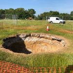
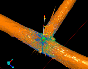
Subsurface laser scan survey of sinkhole in playing field
Geoterra was appointed by Wooburn & Bourne End Parish Council to carry out a 3D subsurface laser scan and video survey of a recently discovered sinkhole in a playing field.
A 3D laser surface survey scan was also required of the... Read more
Tylorstown Landslide UAV LiDAR & Photogrammetry Survey
Geoterra was appointed by The Coal Authority, Capita and Rhondda Cyon Taf Council to carry out a UAV survey using both low-level LiDAR techniques and photogrammetry on a landslide that occurred on a historic legacy coal tip, together with adjacent... Read more
Aerial LiDAR and Photogrammetry Survey of River Usk Embankment
Geoterra was appointed by Newport Council and Capita Property & Infrastructure to monitor a stretch of River Usk embankment for movement using a low-level UAV LiDAR and photogrammetry survey of several phases at monthly intervals. This would be an ongoing... Read more
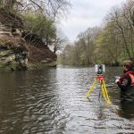
Salvesen Steps 3D Laser Scan Survey
Geoterra was appointed by Edinburgh Council and SWECO to carry out a highly detailed 3D laser scan and UAV LiDAR survey of a rock face and adjacent land that ran approximately 150m along the River Almond incorporating the Weir, Cramond... Read more
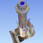
3D Laser Scan Survey of Victorian Brick-Built Chimney
Geoterra was appointed by The Canal and River Trust to carry out a 3D topographical laser scan survey both internally and externally of a historic Victorian brick-built chimney at the National Waterways Museum, Ellesmere Port, Cheshire.
The survey data was required... Read more
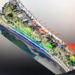
A UAV LiDAR and Photogrammetry Survey of King George V Memorial Embankment
Geoterra was appointed by Cormac Consulting to carry out a UAV survey using photogrammetry and low-level LiDAR techniques on a residential/leisure land, which had moderate low-level vegetation cover at the time of the survey adjacent to the tidal estuary at... Read more
Services
News

Get In Touch
Winnington Hall
Winnington Lane
Northwich
Cheshire
CW8 4DU
Phone: +44 (0)1606 659019Fax: Not AvailableEmail: info@geoterra.co.uk


