Subsurface Laser Scanning - Projects
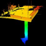
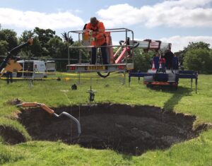
Underground 3D laser scan survey of second sinkhole and bell pit on playing field
In February 2020, Geoterra surveyed a sinkhole and bell pit that had appeared on Sappers Field in Wooburn Green. This sinkhole and bell pit was backfilled and remediated by Soil Engineering in 2022.
Prior to being a playing field, the... Read more
Subsurface Laser Scan Survey of Historic Lead Mine Shaft
Geoinvestigate appointed Geoterra to carry out a 3D subsurface laser scan and HD video survey of a historic lead mine shaft. The mine potentially dated back to the 1700s when the Talargoch mine was extracting lead ore. The lead mine... Read more
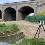
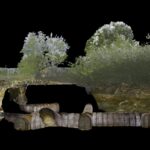
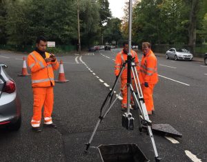
Drainage Culvert Survey Beneath East Coast Main Line
Geoterra was appointed by AMCO Giffen and Network Rail to carry out a 3D topographical laser scan survey of the surface, and a subsurface laser scan and remote UAV photogrammetry survey of a brick-built drainage culvert. This culvert had been... Read more
Subsurface Laser Scan and UAV Photogrammetry Survey of Air Raid Shelter
Geoterra was appointed by M-AR and Bromley Council to carry out a 3D topographical laser scan survey above and below ground, as well as a remote UAV photographic survey of a historic air raid shelter. The air raid shelter had... Read more

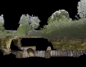
Historic Coal Mine Subsurface Laser Scan Survey
Geoterra was appointed by The Coal Authority to determine the location, size and orientation of an historical coal mine void that had been discovered beneath a main road and its adjacent properties.
The coal mine had been discovered... Read more
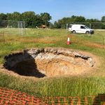
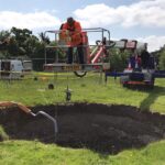
Subsurface laser scan survey of sinkhole in playing field
Geoterra was appointed by Wooburn & Bourne End Parish Council to carry out a 3D subsurface laser scan and video survey of a recently discovered sinkhole in a playing field.
A 3D laser surface survey scan was also required of the... Read more
Services
News


Get In Touch
Winnington Hall
Winnington Lane
Northwich
Cheshire
CW8 4DU
Phone: +44 (0)1606 659019Email: info@geoterra.co.uk


